
Latest Science News
Magnetic North Pole moving 55 km a year, scientists update world magnetic model

[vc_row][vc_column][vc_column_text]On Monday, scientists released an update of where true north really was.
Such updates are nothing new and usually happen every five years, but this time it came nearly a year ahead of schedule because the Earth’s north magnetic pole is shifting fast – about 55 km a year – in the last few decades rendering past estimates no longer accurate enough for precise navigation.
The magnetic north pole crossed the international date line in 2017, and is leaving the Canadian Arctic on its way to Siberia. Its movement has become really fast – about five times its previous rate – and no one can explain why.
The constant shift is a problem for compasses in smartphones and some consumer electronics. Airplanes and boats also rely on magnetic north, usually as backup navigation, said University of Colorado geophysicist Arnaud Chulliat, lead author of the newly issued World Magnetic Model.
GPS isn’t affected because it’s satellite-based.
Magnetic north is one of three “north poles” on our globe. First, there’s true north, which is the northern end of the axis on which the Earth rotates.
But our planet’s protective magnetic bubble, or magnetosphere, isn’t perfectly aligned with this spin, explained National Geographic (NG). Instead, the dynamo of Earth’s core creates a magnetic field that is slightly tilted from the planet’s rotational axis. The northern end of this planet-size bar magnet is what’s known as geomagnetic north — a point sitting off the northwest coast of Greenland that’s changed position little over the last century.
Then there’s magnetic north, what your compass locates, which is defined as the point at which magnetic field lines point vertically down. Unlike geomagnetic north, this position is more susceptible to the surges and flows in the swirl of liquid iron in the core, said NG. These currents tug on the magnetic field, sending magnetic north hopping across the globe.
The military depends on where magnetic north is for navigation and parachute drops, while NASA, the Federal Aviation Administration, and the US Forest Service also use it.
Airport runway names are based on their direction toward magnetic north and their names change when the poles move. For example, the airport in Fairbanks, Alaska, renamed a runway 1L-19R to 2L-20R in 2009.
The US and the United Kingdom tend to update the location of the magnetic north pole every five years in December, but this update came early because of the pole’s faster movement.
Since 1831 when it was first measured in the Canadian Arctic, the magnetic north pole has moved about 2300 kilometers toward Siberia. Its speed jumped from about 11 km per year to 55 km per year since 2000.

The reason is turbulence in Earth’s liquid outer core about 2897 km below the surface. There is a hot liquid ocean of iron and nickel in the planet’s core and its motion generates an electric field, said University of Maryland geophysicist Daniel Lathrop, who wasn’t part of the team monitoring the magnetic north pole.
The magnetic south pole is moving far slower than the north.
In general Earth’s magnetic field is getting weaker, leading scientists to say that it will eventually flip, where north and south pole changes polarity, like a bar magnet flipping over. It has happened numerous times in Earth’s past, but not in the last 780,000 years.
“It’s not a question of if it’s going to reverse, the question is when it’s going to reverse,” Lathrop said. When it reverses, it won’t be like a coin flip, but take 1,000 or more years, experts said.
Lathrop sees a flip coming sooner rather than later because of the weakened magnetic field and an area over the South Atlantic has already reversed beneath Earth’s surface.
It is only in recent years, scientists noticed, that magnetic north’s movement has shifted into high gear, sending it galloping across the Northern Hemisphere — and no one can entirely explain why.
The changes have been so large that scientists began working on an emergency update for the World Magnetic Model, the mathematical system that lays the foundations for navigation, from cell phones and ships to commercial airlines. But then the US government shut down, placing the model’s official release on hold, as Nature News first reported earlier this year.
Finally, the World Magnetic Model update was officially released on Monday, and magnetic north can again be precisely located for people around the world.
The World Magnetic Model
To account for the periodic shift of magnetic north, the World Magnetic Model was developed by the US National Oceanic and Atmospheric Administration (NOAA) and the British Geological Survey (BGS) “so they would all be on the same map, essentially,” says Ciaran Beggan, a geophysicist with the BGS.
The model is updated every five years, with the last update in 2015. Between each update, scientists check the model’s accuracy against data from ground magnetic observatories and the European Space Agency’s Swarm mission—a trio of magnetic-field mapping satellites that zip around Earth 15 to 16 times each day. Until now, this seemed sufficient to keep up with magnetic north’s march toward Siberia.
In the mid 1900s, the north magnetic pole was lumbering along at less than a hundred feet each day, adding up to less than 11km of difference each year. But in the ’90s, this started to change and by the early 2000s, it had speeded up five times to some 55 km each year.
“Things are acting very strangely at high latitude,” says Livermore, who notes that this increase seemed to coincide with a strengthening jet in the planet’s liquid outer core. Though the events could be linked, it’s not yet possible to say for sure.
By early 2018, scientists realized that the model would soon exceed the acceptable limits for magnetic-based navigation. Something had to be done before the model’s next regular update, slated for 2020.
To correct the model, NOAA and BGS scientists tweaked it using three years’ worth of recent data. This updated version was pre-released online in October 2018.
The government shutdown delayed the comprehensive public release of the information, which includes online calculators, software, and a technical note describing the changes. In principal, everyone who uses magnetic navigation could benefit from this update, says Arnaud Chulliat, a geomagnetist at the University of Colorado in Boulder and a NOAA affiliate who worked on the update.
Whether this change affect will you
The model has found its way into many of our modern mapping systems, including Google and Apple, Beggan adds. But the difference is minor for most civilian purposes, and the changes are mainly limited to latitudes above 55 degrees.
“The average user is not going to be overly affected by this unless they happened to be trekking around the high Arctic,” Beggan says.
Animals that use Earth’s magnetic field for navigation — including birds, salmon, and sea turtles — could get lost during their routine journeys but, eventually, they will sort this out and, all other things being equal, life will go on, the NG report said.
An overall weakening of the magnetic field isn’t good for people and especially satellites and astronauts. The magnetic field shields Earth from some dangerous radiation, Lathrop said.
When the poles do reverse, Earth’s magnetic field could get weaker — but its strength is already quite variable, so that’s not necessarily unusual, and there’s no indication it will vanish entirely, according to NASA. It never has.
One total bonus of having a weaker magnetic field is that auroras will be visible from much lower latitudes, so the nighttime skies will be even more epic.
If the magnetic field gets substantially weaker and stays that way for an appreciable amount of time Earth will be less protected from the high-energy particles flying around in space. This means that everything on the planet will be exposed to higher levels of radiation, which over time could produce an increase in diseases like cancer, as well as harm delicate spacecraft and power grids on Earth.
These are consequences we can prepare for. For now, said the NG report, we’re doing a decent job of introducing carcinogenic toxins to the environment and otherwise altering the ways in which ecosystems normally function, so there are bigger things to worry about in the short term.
[/vc_column_text][/vc_column][/vc_row]
Latest Science News
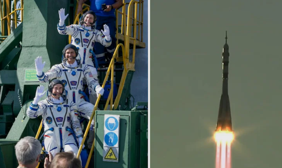
Indian-origin astronaut Anil Menon begins first mission to International Space Station
Indian-origin NASA astronaut Anil Menon has launched aboard Soyuz MS-29 on his first mission to the International Space Station, where he is expected to spend around eight months conducting research.
Latest Science News
Astronaut Shubhanshu Shukla to meet PM Modi after return from historic space mission
Astronaut Shubhanshu Shukla, who recently returned from the ISS as part of the Axiom-4 mission, will meet PM Modi this evening. Parliament will also hold a special discussion on his historic journey.

India News
Shubhanshu Shukla pens emotional note as he returns to India after space mission
Indian astronaut Shubhanshu Shukla penned an emotional Instagram post as he returned to India after his 18-day ISS mission, marking a milestone in India’s space journey.


Pralhad Joshi: From student leader to Education Minister, a look at his political journey

UP Government forms new SIT led by 3 IPS officers to probe Ayodhya Ram Temple donation theft

Assam flood death toll rises to 66, over 6.5 lakh people still affected

Amit Shah praises Dharmendra Pradhan’s resignation, says Nation above post
Amit Shah praises Dharmendra Pradhan’s resignation, says Nation above post
Assam flood death toll rises to 66, over 6.5 lakh people still affected
UP Government forms new SIT led by 3 IPS officers to probe Ayodhya Ram Temple donation theft
Pralhad Joshi: From student leader to Education Minister, a look at his political journey

Pralhad Joshi appointed Education Minister after Dharmendra Pradhan’s resignation
Afghan Men Try To Hang With The Jet Engine Of The Aircraft in Kabul- Afghanistan News – Kabul News
Trending Top 10 News: 10000 Crore Fine on Flipkart, Apple to Launch Unique Feature, Hdfc Bank Job Ad
Trending Top 10 News: Nokia 6310, Apple sales, Bachpan ka Pyar Video Kid, Dainik Bhaskar IT Raid
Trending Top 10 News: Canada bans Indian flights, Rain in Delhi NCR, AIMIM Twitter hacked, Raj Kundra case
Trending Top 10 News: Shein India, Apple New Service, Pocket Oxygen, Oppo Launched New Phone
-
 India News20 hours ago
Pralhad Joshi: From student leader to Education Minister, a look at his political journey
-
 India News19 hours ago
UP Government forms new SIT led by 3 IPS officers to probe Ayodhya Ram Temple donation theft
-
 India News19 hours ago
Assam flood death toll rises to 66, over 6.5 lakh people still affected
-
 India News19 hours ago
Amit Shah praises Dharmendra Pradhan’s resignation, says Nation above post